
Tags
Arctic air, freezing rain, gusty winds, Lake-effect snowfall, record cold weather, snow, US weather, weather
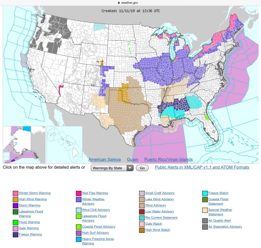
“Early Wintry Conditions for much of the Eastern 2/3rds of the U.S.; Warm and Stagnant Air in the West Arctic air will bring snow, freezing rain, gusty winds, and some of the coldest temperatures of the season east of the Rockies early this week. Heavy snow with potential for freezing rain will be possible for a wide swath of New York. Lake effect snow will produce heavy snow downwind of the Great Lakes. Warm temperatures continue in the West along with air quality issues in the interior Northwest” https://www.weather.gov
“Short Range Forecast Discussion
NWS Weather Prediction Center College Park MD
311 AM EST Mon Nov 11 2019
Valid 12Z Mon Nov 11 2019 – 12Z Wed Nov 13 2019
…The coldest surge of arctic air so far this season will bring
widespread record low temperatures for much of the central and eastern
U.S. even down to the Gulf Coast…
…Accumulating snow is expected to impact areas from the Great Lakes to
northern New England…
The coldest surge of arctic air so far this season is well under way
across the northern tier states. Sub-zero temperatures are now observed
over the northern High Plains as a strong and expansive high pressure
system from the Arctic settles into the region. The strength of this
arctic high, with central pressure forecast to be above 1045 mb, will
bring near record high pressure for November across the High Plains. But
the more sensible aspect of this arctic intrusion will be the widespread
cold temperatures that will likely set record low temperatures across many
locations from the Plains eastward to the East Coast and down into the
Deep South through Wednesday. In fact, below freezing temperatures are
forecast as far south as the central Texas coast by Wednesday morning.
This will make it feel like in the middle of winter rather than in
November for much of the eastern two-thirds of the country for the next
few days.
In addition to the arctic cold, snow is expected to fall across a wide
area behind the arctic cold front. Much of the areas from the northern
Rockies through the northern Plains and upper Midwest continue to see snow
falling this Monday morning well behind the arctic front. The snow over
the northern and central Rockies is expected to gradually taper off today.
But as the main upper-level jet stream moves toward the Great Lakes, a
low pressure center is expected to form and intensify along the arctic
front over the Ohio Valley tonight. Snow will then pick up in intensity
over upstate New York and northern New England tonight as the low pressure
center passes just to the south. 6 to 12 inches of snow with locally
higher amounts are forecast for northern New York and northern Vermont by
Wednesday morning. Farther west, lake-effect snowfall is likely downwind
of the Great Lakes where locally more than a foot can be expected.
Behind the strong arctic high, an upper-level impulse will bring the next
chance of snow and mixed precipitation across the Pacific Northwest into
the northern Rockies Tuesday and Tuesday night. The precipitation will
likely move into the northern Plains in the form of snow early on
Wednesday.
Meanwhile, showers are likely with the passage of the arctic front across
the South today, with the heaviest rainfall over Arkansas and northern
Louisiana where an inch of rain is possible. Some locations over the
Mid-Atlantic could see rain changing to snow during the day on Tuesday
before the arctic front moves off the coast, ending the precipitation.
In contrast, locations west of the Rockies will be spared from the Arctic
airmass, with above average temperatures expected from the Desert
Southwest to the Pacific Northwest.” https://www.weather.gov


You must be logged in to post a comment.