
Tags
California, fire, hazard, LA, Los Angeles, Nuclear Power Stations, risk, Santa Ana Winds, Southern California, Thomas Wildfire, US Highway 101, Ventura, Ventura Wildfire
If you are getting rain or snow be grateful.

https://www.nesdis.noaa.gov/content/imagery-and-data
“The Ventura wildfire exploded to nearly 80 square miles (207 square kilometers) in a matter of hours. It was fanned by dry Santa Ana winds clocked at well over 60 mph (96 kph) and spit embers up to a half-mile (0.8 kilometers) ahead of fire lines.” (“California Communities Under Siege From Wind-driven Fires“, December 05, 2017 10:30 PM) https://www.voanews.com/a/california-wildfire-ruins-hundreds-homes/4151190.html
“11:50 p.m.: – The biggest and most destructive wildfire burning in Southern California has jumped U.S. Highway 101, nearly reaching the ocean and forcing new evacuations.” (California Wildfire Hops Highway, Nears Ocean, Tuesday, December 5, 2017, Sacramento, CA. http://www.capradio.org/articles/2017/12/05/southern-california-wildfire-burns-150-structures-winds-increasing )
California Fire Maps and more: http://www.fire.ca.gov
http://www.fire.ca.gov/communications/communications_firesafety_redflagwarning
Overlays of NOAA weather forecast, Near Real Time Fire Data, and San Onofre and Diablo Canyon Nuclear Power Stations. This is just to give a general idea. Fire data changes by the second. From Day 1 to Day 2 Forecast extreme area expands well into the critical area. See population and land area at risk on twin maps below.


48 H Fire Data Source: https://earthdata.nasa.gov/earth-observation-data/near-real-time/firms/active-fire-data Fire Weather Outlook Source: http://www.spc.noaa.gov/products/fire_wx/fwdy1.html
http://www.spc.noaa.gov/products/fire_wx/fwdy2.html
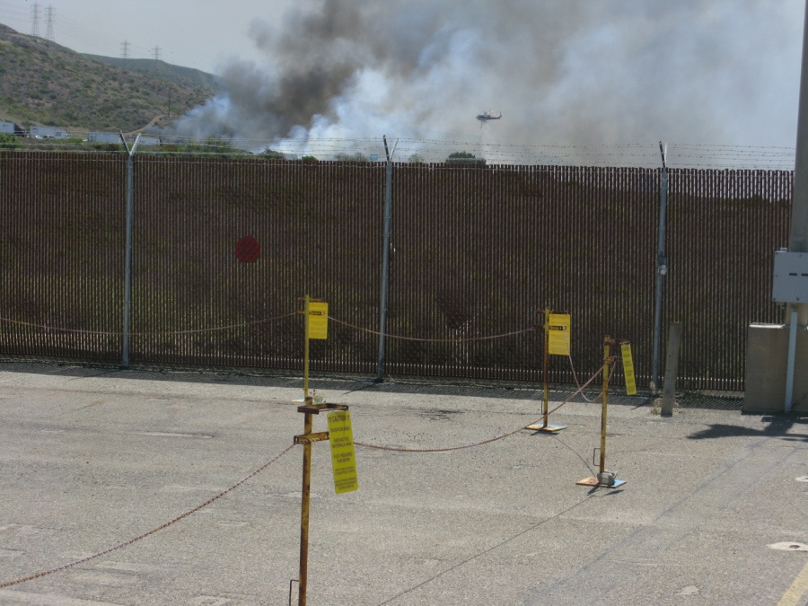
2014 Fire Near San Onofre Nuclear Power Station
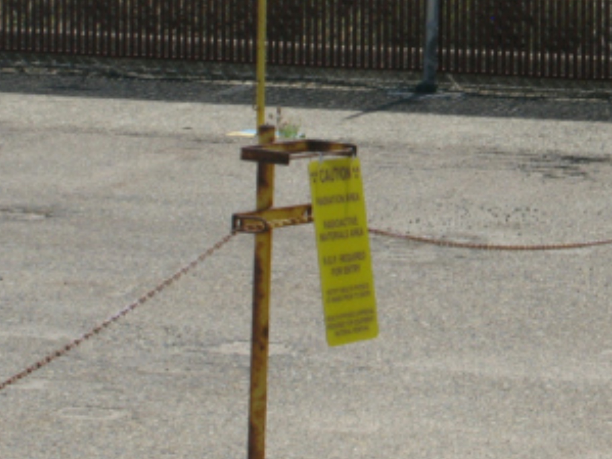
Zoom showing that the yellow indicates radioactive area
FORECAST DETAILS:
“ZCZC SPCFWDDY1 ALL
FNUS21 KWNS 060718
Day 1 Fire Weather Outlook
NWS Storm Prediction Center Norman OK
0118 AM CST Wed Dec 06 2017
Valid 061200Z – 071200Z
…EXTREMELY CRITICAL FIRE WEATHER AREA FOR PORTIONS OF VENTURA AND LOS ANGELES COUNTIES FOR LATE TONIGHT IN SOUTHERN CALIFORNIA… …CRITICAL FIRE WEATHER AREA FOR PORTIONS OF SOUTHERN CALIFORNIA…
…Synopsis…
Critical fire weather conditions will continue today and tonight
across parts of southern CA as moderate to strong Santa Ana winds
occur.
Extremely critical conditions now appear likely across parts
of Ventura and Los Angeles counties late tonight into early Thursday
morning. These dangerous high-end critical to extremely critical
conditions will continue into Day 2/Thursday.
A highly amplified upper pattern will remain across the CONUS today
as a large-scale upper trough/low encompasses the central/eastern
CONUS. An upper ridge will be centered over the eastern Pacific and
western CONUS. At the surface, a strong and broad area of high
pressure will remain across the northern Rockies and Great Basin
through the period. Generally cool post-frontal conditions will
temper fire weather concerns east of the Rockies.
…Portions of Southern CA…
The LAX-TPH surface pressure difference has averaged around -11.8 mb
over the past few hours. Corresponding strong/gusty northeasterly to
easterly winds of generally 20-30 mph continue per recent surface
observations across much of the higher terrain of coastal southern
CA. Higher gusts of 40-50 mph have been observed as well.
A prolonged offshore wind event will continue across parts of
southern CA today as the surface pressure gradient remains strong
enough to support 20-30 mph northeasterly/easterly sustained winds.
Gusts of 40-50 mph will likely continue across the
mountains/foothills of coastal southern CA. RH values will remain
critically lowered in the 5-15% range owing to both low-level
downslope warming/drying and diurnal heating, with very poor to
nonexistent overnight recovery. Latest deterministic and ensemble
guidance indicates that the surface pressure gradient will be
somewhat weaker through at least the first half of the Day
1/Wednesday period compared to yesterday.
Still, high-end critical conditions will remain likely in favored higher terrain, and with
very dry fuels in place, large fire spread will occur with any
new/ongoing fires.
Confidence has increased that the surface pressure gradient will
restrengthen late tonight into early Thursday morning, and a
corresponding increase in wind speeds/gusts will occur in this time
frame. Both the 3 km NAM and experimental HRRR indicate sustained
winds of 30-35 mph and sub-10% RH values will occur across portions
of Ventura and Los Angeles counties for the last few hours of the
Day 1/Wednesday period. Therefore, a small extremely critical area
has been introduced to account for this threat. Extremely critical
conditions are expected to become more widespread across coastal
southern CA on Day 2/Thursday. See the Day 2 Fire Weather Outlook
for more information.
..Gleason.. 12/06/2017
…Please see http://www.spc.noaa.gov/fire for graphic product…
http://www.spc.noaa.gov/products/fire_wx/fwdy1.html
“
ZCZC SPCFWDDY2 ALL
FNUS22 KWNS 060718
Day 2 Fire Weather Outlook
NWS Storm Prediction Center Norman OK
0118 AM CST Wed Dec 06 2017
Valid 071200Z – 081200Z
…EXTREMELY CRITICAL FIRE WEATHER AREA FOR PORTIONS OF SOUTHERN
CALIFORNIA…
…CRITICAL FIRE WEATHER AREA FOR PORTIONS OF SOUTHERN CALIFORNIA…
…Synopsis…
Dangerous and extremely critical fire weather conditions are
expected across a greater portion of southern CA on Day 2/Thursday
compared to Day 1/Wednesday.
Within large-scale upper troughing over much of the central/eastern
CONUS, an embedded positively tilted upper trough will develop
south-southeastward over the Rockies/Plains by 12Z Thursday.
Enhanced north/northeasterly low- and mid-level flow around 30-40 kt
on the western periphery of this upper trough will overspread the
Southwest and southern CA Thursday morning and early afternoon.
Highly amplified upper ridging will remain over the eastern Pacific
and West Coast.
At the surface, a broad area of high pressure over the northern
Rockies and Great Basin will restrengthen late from Wednesday night
into Thursday morning. A corresponding increase in offshore winds
will occur across much of coastal southern CA through Thursday
evening, supporting high-end critical to extremely critical fire
weather conditions.
…Portions of Southern CA…
Given the strengthening surface pressure gradient plus the enhanced
low- and mid-level flow mentioned above, sustained northeasterly to
easterly winds of 30-40 mph will likely occur across much of the
higher terrain of southern CA from Thursday morning through at least
the evening hours.
This includes the mountains/foothills and
adjacent areas of Ventura, Los Angeles, Orange, southwestern San
Bernardino, western Riverside, and central/eastern San Diego
counties. Stronger gusts of 50-70 mph will likely occur in favored
higher terrain and passes where flow channeling will be maximized.
RH values will easily fall/remain in the 5-10% range due to diurnal
heating and low-level downslope warming/drying effects. Coupled with
very dry/receptive fuels, these expected meteorological conditions
support an extremely critical fire weather area. Large fire spread
and extreme fire behavior will occur with any new/ongoing fires.
Surrounding the extremely critical designation, critical fire
weather conditions are anticipated. Here, sustained winds of 20-30
mph, with gusts to 40-50 mph, and RH values of 5-15% will be common.
Both downtown Los Angeles and the LA basin along with San Diego have
been included in a critical delineation. These dangerous fire
weather conditions are forecast to continue through the entire Day
2/Thursday period, although the surface pressure gradient should
relax slightly from late Thursday night into Friday morning. This
should act to lessen winds somewhat across southern CA late in the
period.
..Gleason.. 12/06/2017
…Please see http://www.spc.noaa.gov/fire for graphic product…”
http://www.spc.noaa.gov/products/fire_wx/fwdy2.html
“ZCZC SPCFWDD38 ALL
FNUS28 KWNS 052109
Day 3-8 Fire Weather Outlook
NWS Storm Prediction Center Norman OK
0309 PM CST Tue Dec 05 2017
Valid 071200Z – 131200Z
…Days 3-6/Thu-Sun — Portions of Southern California…
Critical fire weather conditions will continue across coastal
southern California through at least Friday afternoon. The last few
run of medium range guidance indicated that Thursday could see more
widespread extremely critical conditions across the mountains and
foothills of the greater Los Angeles and San Diego areas. The
forecast surface pressure gradient early Day 3/Thursday will be
similar to that on Day 1/Tuesday morning and intense winds with
single digit to 10 percent RH values will be common. Temperatures
also will be warmer on Thursday as an upper level ridge amplifies
along the Pacific coast.
Critical conditions likely will continue into Friday before the
surface pressure gradient begins to relax on Saturday and Sunday,
though elevated fire conditions likely will persist into the
weekend.
An amplified pattern will persist across the U.S. through
much of the Day 3-8 period with a deep upper trough over the eastern
U.S. and the upper ridge over the western states.
Surface highpressure also will remain over the interior west, maintaining an
offshore gradient across southern California. This will result in
continued offshore winds, though these winds should be much weaker
by Sunday into next week. While wind speeds will decrease by early
next week, very dry conditions will continue.
…Day 4/Friday — Portions of the Central and Southern High
Plains…
Gusty northwesterly winds are expected behind a cold frontal passage
on Friday afternoon. A very dry airmass will be in place and RH
values will fall near or below the critical threshold. Dormant fine
fuels and a lack of recent precipitation will lead to at least
elevated fire weather conditions and possible upgrades to critical
may be needed if current trends continue.
..Leitman.. 12/05/2017
…Please see http://www.spc.noaa.gov/fire for graphic product…”
http://www.spc.noaa.gov/products/exper/fire_wx/

You must be logged in to post a comment.