
Tags
check valve, Colorado River, corrosion, dam failure, dam failure vulnerability, dam tsunami, degradiation, flooding, Fukushima, Gulf of Mexico, Hurricane Harvey, hurricane safety, manholes, NASA, radiation damage, Rain, saltwater, satellite images, sealant, South Texas Nuclear, South Texas Nuclear Project, Storm Surge, STP Nuclear Operating Station, US NRC, US NRC Flood Walkdown, valves, water, Waterproof, watertight
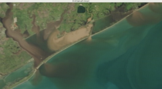
August 31st NASA Earth Observatory image by Jesse Allen, using data from the Land Atmosphere Near real-time Capability for EOS (LANCE) Zoom in of image shows the huge main cooling reservoir-dam at the South Texas Nuclear Power Station site – green spot top center of image – apparently still intact as of August 31st, though the nearby waterways continue(d) to rise.
“The STP site has mainly flat topography with few gentle slopes. Elevations across the site range from 15ft (4.6 m) NGVD29 to 30ft (9.1 m) NGVD29 with plant grade of 28ft (8.53 m) NGVD29.” https://www.nrc.gov/docs/ML1425/ML14259A195.pdf
If you read, or even just glance, through the US NRC’s flooding walkdown summary, below, then you will quickly get ideas as to to what the “one thing after another” that Raihan Kondker was “working tirelessly to manage” at South Texas Nuclear Power Station, according to the article “Canadian expats in Texas brave remnants of Hurricane Harvey“, might consist of. In a 2015 NRC document, Raihan Khondker is listed as STP Engineer Sr, Equipment Reliability. According to his linked in page, his experience includes maintenance, and corrosion engineering. The fact that he had to drive through flood waters to bring supplies because engineers were running out of food, according to the article, speaks volumes about the disorganization and lack of planning. He was interviewed in an article found at The Star .com and Metro News .ca entitled “Canadian expats in Texas brave remnants of hurricane Harvey Harvey slammed into Texas as a Category-4 hurricane. It has been downgraded to a tropical storm.” By The Canadian Press Sun., Aug. 27, 2017
Post Fukushima Flood Walkdown Highlights for STP Nuclear
“The postulated failure of the MCR [Main Cooling Reservoir] is estimated by the licensee to result in a flood level elevation of 50.8 feet (ft) mean sea level (MSL), while plant grade is at 28.0 ft MSL. The licensee stated that an instantaneous water level of 50.2 ft National Geodetic Vertical Datum (NGVD) is reached 38 seconds after the breach as determined in the STP Updated Final Safety Analysis Report (UFSAR), and a maximum flood height of 50.8 MSL is used as the design basis flood.” Is this NGVD of 1929, which they are generally using instead of the 1988 version? They don’t say. They anticipate a water level of a little more than 22 ft (50.2 ft – 28 ft). Notice that they say that it will reach the level in 38 seconds after the breach. However, it takes them up to 30 minutes “to close two normally open watertight doors“. STP argues that this is reasonable because “indication of potential MCR breach would be available in advance.” But it may not be known in advance and there “are no credited external flooding warning systems installed at the STP site. However, as stated by the licensee the flood detectors are present in building sumps for detection of internal flooding.”
The Nuclear Reactor containment building was already leaking without flooding, they found: “The walkdown report states that for STP Unit 1, some groundwater leaks into ‘the 64 degree tendon buttress area’in the Reactor Containment Building and is collected in a sump.” In the walkdown they more generally found “minor degradation of features including light corrosion, small cracks in penetration seals, discolored Hydrosil (sealant), and dried and cracked boot seals.” And, it won’t be getting better as corrosion is enhanced due to the nearby saltwater in the Gulf of Mexico and the radioactive environment also speeds up degradation. They may do repairs but problems will continue. There is a list of things like problems with supposedly watertight door and manhole seals and lack of restraints to keep doors and manholes shut, found during the walkdown. Some things were inaccessible and cannot be checked or not easily so: “The licensee determined that flooding protection seals, penetration seals in a manhole, flood penetration seals were inaccessible. Flooding penetration seals were inaccessible due to a location within a high radiation area.“ STP falsely argues that “Based on inspection of similar seals constructed of the same material and subject to the same environmental conditions, the licensee stated that it can be reasonably assured that these seals will perform their intended function for the full duration of the flood condition.” The same environmental conditions would have to include high radiation levels which degrade materials at a faster rate, and this apparently isn’t the case. Thus, whether or not the STP Nuclear Power Station can adequately keep out water in a serious flooding condition appears fairly debatable. Read more details in the flood walkdown summary below Beyond Nuclear – Paul Gunter’s comment.
Paul Gunter, Director of the Reactor Oversight Project with Beyond Nuclear explains that “ a breach of the embankment wall would create an external flood potentially impacting the electrical supply from the switchyard to the reactor safety systems. This could cause high-energy electrical fires and other cascading events initiating a severe accident leading to core damage. Additionally, any significant loss of cooling water inventory in the Main Cooling Reservoir would reduce cooling capacity to the still operating reactors that could result in a meltdown.“ He also informs us that “the top of the cooling reservoir wall is between 65 and 67 feet above mean sea level” and that “NRC is not providing a status report on the water level in the reservoir where the normal maximum operating level is 49 feet above mean sea level.” Emphasis our own. See: “Credible Threat of Severe Accident at Texas Nuclear Reactors Still Running During Hurricane, Beyond Nuclear News Release“: https://www.commondreams.org/newswire/2017/08/29/credible-threat-severe-accident-texas-nuclear-reactors-still-running-during


“SOUTH TEXAS PROJECT, UNITS 1 AND 2- STAFF ASSESSMENT OF THE FLOODING WALKDOWN REPORT”
Click to access ML14150A191.pdf
Land shifting near the South Texas Nuclear Power Station could impact earthen dam stability. It is also why they need to use a more recent elevation standard. For earthen dams-levees like this one, burrowing animals can and have led to dam-levee failure.

Below is the regular Google map image with Harvey location super-imposed.

The Colorado River passes near the South Texas Nuclear site.

Katrina levee breach FEMA gov


You must be logged in to post a comment.