
Tags
Alabama, Florida, Florida Panhandle, Georgia, Hurricane Michael, Hurricane Michael advisory, hurricane warning, hurricane watch, hurricane wind speeds, Joseph Farley Nuclear Power, North Carolina, Nuclear Power Station, Savannah River Nuclear Site, South Carolina, Storm Surge, US Gulf Coast
For the most up to date information on Hurricane Michael and other tropical weather go to https://www.nhc.noaa.gov and https://www.weather.gov Stay alert for updates/forecast changes at the NHC and weather gov links.
Hurricane Michael ca 9.12 CDT nearing landfall.
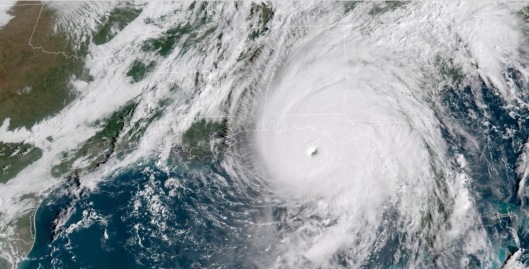
Hurricane Michael just before dawn on October 10, 2018. Note the perfect eye, which was lacking yesterday, now making it the perfect storm, in every sense of the word.


Click to access nws-tae-briefing.pdf
SEE 5 AM, 6 AM, 7 AM and 8 AM UPDATES/ADVISORIES BELOW THE IMAGES
Hurricane Michael wind impact areas and nuclear power stations-facilities (orange skulls)
The descriptions are those expected for the wind speeds in the color zones described, starting with purple.


https://www.weather.gov/srh/tropical?office=tbw
Nuclear power stations are dangerous and unreliable electricity sources in extreme weather. One of the most dangerous, and often ignored, things about nuclear energy is that nuclear power stations always have need for backup energy supplies for cooling of the nuclear reactors, and spent fuel pools, as dramatically demonstrated by the never-ending Fukushima Daiichi nuclear disaster. If they lose offsite power, then they are dependent upon backup generators, which can fail to start, fail once started or run out of fuel. https://miningawareness.wordpress.com/2018/09/03/tropical-storm-watch-for-us-gulf-coast-2-am-update-reminder-of-the-dangers-of-mixing-severe-weather-with-nuclear-power-another-tropical-storm-in-atlantic/
A good thing there’s no nuclear power station out on a sandbar in the area, like St. Lucie nuclear power station on the Atlantic coast of Florida.

National map showing pressure system/fronts pushing/guiding Hurricane Michael

“000
WTNT64 KNHC 101252
TCUAT4
Hurricane Michael Tropical Cyclone Update
NWS National Hurricane Center Miami FL AL142018
800 AM CDT Wed Oct 10 2018
…8 AM CDT POSITION UPDATE…
…WATER LEVELS QUICKLY RISING AND WINDS INCREASING ALONG THE
FLORIDA PANHANDLE AS POTENTIALLY CATASTROPHIC MICHAEL APPROACHES…
A National Ocean Service station at Apalachicola recently reported
a sustained wind of 40 mph (65 km/h) and a wind gust of 53 mph (85
km/h).
SUMMARY OF 800 AM CDT…1300 UTC…INFORMATION
———————————————–
LOCATION…29.1N 86.2W
ABOUT 80 MI…130 KM SSW OF PANAMA CITY FLORIDA
ABOUT 85 MI…135 KM WSW OF APALACHICOLA FLORIDA
MAXIMUM SUSTAINED WINDS…145 MPH…230 KM/H
PRESENT MOVEMENT…N OR 10 DEGREES AT 13 MPH…20 KM/H
MINIMUM CENTRAL PRESSURE…933 MB…27.55 INCHES
$$
Forecaster Brennan
https://www.nhc.noaa.gov/text/refresh/MIATCUAT4+shtml/101252.shtml
“000
WTNT34 KNHC 101145
TCPAT4
BULLETIN
Hurricane Michael Intermediate Advisory Number 15A
NWS National Hurricane Center Miami FL AL142018
700 AM CDT Wed Oct 10 2018
…POTENTIALLY CATASTROPHIC HURRICANE MICHAEL HEADING TOWARD THE
FLORIDA PANHANDLE…
…LIFE-THREATENING STORM SURGE…HURRICANE FORCE WINDS…AND HEAVY
RAINFALL IMMINENT…
SUMMARY OF 700 AM CDT…1200 UTC…INFORMATION
———————————————-
LOCATION…29.0N 86.3W
ABOUT 90 MI…145 KM SW OF PANAMA CITY FLORIDA
ABOUT 90 MI…145 KM WSW OF APALACHICOLA FLORIDA
MAXIMUM SUSTAINED WINDS…145 MPH…230 KM/H
PRESENT MOVEMENT…N OR 10 DEGREES AT 13 MPH…20 KM/H
MINIMUM CENTRAL PRESSURE…933 MB…27.55 INCHES
WATCHES AND WARNINGS
——————–
CHANGES WITH THIS ADVISORY:
None
SUMMARY OF WATCHES AND WARNINGS IN EFFECT:
A Storm Surge Warning is in effect for…
* Okaloosa/Walton County Line Florida to Anclote River Florida
A Storm Surge Watch is in effect for…
* Anclote River Florida to Anna Maria Island Florida, including
Tampa Bay
A Hurricane Warning is in effect for…
* Alabama/Florida border to Suwannee River Florida
A Tropical Storm Warning is in effect for…
* Alabama/Florida border to the Mississippi/Alabama border
* Suwanee River Florida to Chassahowitzka Florida
* North of Fernandina Beach Florida to Surf City North Carolina
A Tropical Storm Watch is in effect for…
* Chassahowitzka to Anna Maria Island Florida, including Tampa Bay
* Mississippi/Alabama border to the Mouth of the Pearl River
* Surf City North Carolina to Duck North Carolina
* Pamlico and Albemarle Sounds
A Storm Surge Warning means there is a danger of life-threatening
inundation, from rising water moving inland from the coastline. For
a depiction of areas at risk, please see the National Weather
Service Storm Surge Watch/Warning Graphic, available at
hurricanes.gov.
A Hurricane Warning means that hurricane conditions are expected
somewhere within the warning area.
A Tropical Storm Warning means that tropical storm conditions are
expected somewhere within the warning area.
A Storm Surge Watch means there is a possibility of life-
threatening inundation, from rising water moving inland from the
coastline.
A Tropical Storm Watch means that tropical storm conditions are
possible within the watch area.
Interests elsewhere across the southeastern United States should
monitor the progress of Michael.
For storm information specific to your area, including possible
inland watches and warnings, please monitor products issued by your
local National Weather Service forecast office.
DISCUSSION AND OUTLOOK
———————-
At 700 AM CDT (1200 UTC), the eye of Hurricane Michael was located
near latitude 29.0 North, longitude 86.3 West. Michael is moving
toward the north near 13 mph (20 km/h). A turn toward the north-
northeast is expected later this morning, with a turn toward the
northeast expected this afternoon or tonight. A motion toward the
northeast at a faster forward speed is forecast on Thursday and
Friday. On the forecast track, the eye of Michael is expected to
move ashore over the Florida Panhandle later today, move
northeastward across the southeastern United States tonight and
Thursday, and then move off the Mid-Atlantic coast away from the
United States on Friday.
Reports from an Air Force Reserve Hurricane Hunter aircraft
indicate that maximum sustained winds have increased to near 145 mph
(230 km/h) with higher gusts. Michael is an extremely dangerous
category 4 hurricane on the Saffir-Simpson Hurricane Wind Scale.
Some additional strengthening is possible before landfall. After
landfall, Michael should weaken as it crosses the southeastern
United States.
Hurricane-force winds extend outward up to 45 miles (75 km) from
the center and tropical-storm-force winds extend outward up to 185
miles (295 km). A wind gust to 56 mph (91 km/h) was recently
reported at Apalachicola Regional Airport.
The estimated minimum central pressure based on NOAA and Air Force
Reserve Hunter aircraft data is 933 mb (27.55 inches).
HAZARDS AFFECTING LAND
———————-
STORM SURGE: The combination of a dangerous storm surge and the
tide will cause normally dry areas near the coast to be flooded by
rising waters moving inland from the shoreline. The water has the
potential to reach the following heights above ground if peak surge
occurs at the time of high tide…
Tyndall Air Force Base FL to Aucilla River FL…9-14 ft
Okaloosa/Walton County Line FL to Tyndall Air Force Base FL…6-9 ft
Aucilla River FL to Cedar Key FL…6-9 ft
Cedar Key FL to Chassahowitzka FL…4-6 ft
Chassahowitzka to Anna Maria Island FL including Tampa Bay…2-4 ft
WIND: Tropical storm conditions are spreading onshore along the
U.S. Gulf Coast within the warning area, with hurricane conditions
spreading onshore later this morning within the hurricane warning
area. Hurricane conditions will also spread well inland across
portions of the Florida Panhandle, southeastern Alabama and
southwestern Georgia later today and tonight.
Tropical storm conditions are expected to spread northward within
the warning area along the southeast U.S. coast beginning tonight,
and are possible in the watch area by late Thursday and Thursday
night.
RAINFALL: Michael is expected to produce the following rainfall
amounts through Friday…
Florida Panhandle and Big Bend, southeast Alabama, and portions of
southwest and central Georgia…4 to 8 inches, with isolated maximum
amounts of 12 inches. This rainfall could lead to life-threatening
flash floods.
The remainder of Georgia, the Carolinas, and southern Virginia…3
to 6 inches, with isolated maximum amounts of 8 inches. This
rainfall could lead to life-threatening flash floods.
Florida Peninsula, eastern Mid Atlantic, southern New England
coast…1-3 inches.
SURF: Swells generated by Michael will affect the coasts of the
eastern, northern, and western Gulf of Mexico during the next day
or so. These swells are likely to cause life-threatening surf
and rip current conditions. Please consult products from your local
weather office.
TORNADOES: A few tornadoes will be possible across parts of the
Florida Panhandle and the northern Florida Peninsula through this
afternoon. This risk will spread into parts of central and southern
Georgia and southern South Carolina this afternoon and tonight.
NEXT ADVISORY
————-
Next complete advisory at 1000 AM CDT.
$$
Forecaster Brown https://www.nhc.noaa.gov/text/refresh/MIATCPAT4+shtml/101145.shtml
“000
WTNT64 KNHC 101059
TCUAT4
Hurricane Michael Tropical Cyclone Update
NWS National Hurricane Center Miami FL AL142018
600 AM CDT Wed Oct 10 2018
…6 AM CDT POSITION UPDATE…
…TROPICAL-STORM-FORCE WINDS SPREADING ONSHORE OF THE COAST OF THE
FLORIDA PANHANDLE…
NOAA buoy 42039, located about 90 miles (145 km) south-southwest
of Panama City, Florida, recently reported sustained winds
of 60 mph (97 km/h) and a wind gust of 76 mph (122 km/h). A wind
gust to 54 mph (87 km/h) was recently reported at Apalachicola
Regional Airport.
SUMMARY OF 600 AM CDT…1100 UTC…INFORMATION
———————————————–
LOCATION…28.8N 86.3W
ABOUT 105 MI…165 KM SSW OF PANAMA CITY FLORIDA
ABOUT 100 MI…160 KM SW OF APALACHICOLA FLORIDA
MAXIMUM SUSTAINED WINDS…140 MPH…220 KM/H
PRESENT MOVEMENT…N OR 5 DEGREES AT 13 MPH…20 KM/H
MINIMUM CENTRAL PRESSURE…937 MB…27.67 INCHES
$$
Forecaster Brown
https://www.nhc.noaa.gov/text/refresh/MIATCUAT4+shtml/101059.shtml
000
WTNT64 KNHC 100956
TCUAT4
Hurricane Michael Tropical Cyclone Update
NWS National Hurricane Center Miami FL AL142018
500 AM CDT Wed Oct 10 2018
…5 AM CDT POSITION UPDATE…
…RAINBANDS OF MICHAEL SPREADING ACROSS THE FLORIDA PANHANDLE…
The latest minimum central pressure estimated from Air Force
Reserve Hurricane Hunter aircraft data has fallen to 937 mb
(27.67 inches). NOAA buoy 42039 recently reported sustained winds
of 60 mph (97 km/h) and a wind gust of 67 mph (108 km/h).
SUMMARY OF 500 AM CDT…1000 UTC…INFORMATION
———————————————–
LOCATION…28.6N 86.4W
ABOUT 120 MI…195 KM SSW OF PANAMA CITY FLORIDA
ABOUT 115 MI…185 KM SW OF APALACHICOLA FLORIDA
MAXIMUM SUSTAINED WINDS…140 MPH…220 KM/H
PRESENT MOVEMENT…N OR 360 DEGREES AT 13 MPH…20 KM/H
MINIMUM CENTRAL PRESSURE…937 MB…27.67 INCHES
$$
Forecaster Beven
https://www.nhc.noaa.gov/text/refresh/MIATCUAT4+shtml/100956.shtml


You must be logged in to post a comment.