
Tags
Caribbean, dangers of nuclear, environment, Florida, Fukushima, Gulf of Mexico, loss of cooling, loss of power, Louisiana, Mississippi, nuclear, nuclear accident, nuclear disaster, nuclear energy, nuclear meltdown, nuclear power, nuclear reactors, nuclear waste, radioactive waste, risk management, Station Blackout
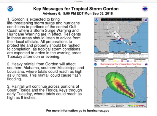
For the most recent updates go to https://www.nhc.noaa.gov , hurricanes.gov and your local weather (e.g. Weather.gov).
Earlier information:
It’s that time again. Time for tropical storms and hurricanes, and time to remember the increased dangers of nuclear power stations (orange skulls on map) during severe weather, which can lead to power outages and power surges, as well as storm surges, flooding and more.

The above map isn’t updated. The map below is Updated: Notice shift northward compared to map below it:

Earlier map:

Nuclear power stations are dangerous and unreliable electricity sources in extreme weather. One of the most dangerous, and often ignored, things about nuclear energy is that nuclear power stations always have need for backup energy supplies for cooling of the nuclear reactors, and spent fuel pools, as dramatically demonstrated by the never-ending Fukushima Daiichi nuclear disaster. If they lose offsite power, then they are dependent upon backup generators, which can fail to start, fail once started or run out of fuel. In Louisiana, a thunderstorm led to a scram at River Bend Nuclear Power Station due to a power surge, followed by a loss of cooling, supposedly the next day. Loss of cooling can lead to a nuclear meltdown, if not corrected quickly enough. https://miningawareness.wordpress.com/2017/10/10/louisiana-nuclear-power-stations-dangerous-problems-with-thunderstorms-hurricane-should-serve-as-reminder-petition-to-intervene-deadline-oct-13th-comment-deadline-oct-23rd-relicensing-must-be
Read more here: https://www.nirs.org/wp-content/uploads/reactorwatch/natureandnukes/nukesandhurricanes092205.pdf (NB: Waterford Nuclear Power Station is near New Orleans going toward Baton Rouge and River Bend Nuclear Power Station is near Baton Rouge).


Map updated: 73 mph winds could require the nuclear power stations to close. Description is for the brown areas near the nuclear power stations.


Map below is earlier update:

Description is forecast for yellow parts of the map. Brown is slightly worse.
National Hurricane Center 5 am updated:
“750
WTNT32 KNHC 030842
TCPAT2
BULLETIN
Potential Tropical Cyclone Seven Advisory Number 3
NWS National Hurricane Center Miami FL AL072018
500 AM EDT Mon Sep 03 2018
…DISTURBANCE LIKELY TO BECOME A TROPICAL STORM TODAY…
…BRINGING HEAVY RAINS TO PORTIONS OF SOUTH FLORIDA…
…TROPICAL STORM WARNING ISSUED FOR A PORTION OF THE NORTHERN GULF
COAST…
SUMMARY OF 500 AM EDT…0900 UTC…INFORMATION
———————————————-
LOCATION…24.5N 80.2W
ABOUT 60 MI…95 KM ESE OF MARATHON FLORIDA
MAXIMUM SUSTAINED WINDS…30 MPH…45 KM/H
PRESENT MOVEMENT…WNW OR 300 DEGREES AT 16 MPH…26 KM/H
MINIMUM CENTRAL PRESSURE…1011 MB…29.86 INCHES
WATCHES AND WARNINGS
——————–
CHANGES WITH THIS ADVISORY:
The Tropical Storm Watch from the Alabama-Florida border westward to
east of Morgan City, Louisiana, including Lake Pontchartrain and
Lake Maurepas has been changed to a Tropical Storm Warning.
SUMMARY OF WATCHES AND WARNINGS IN EFFECT:
A Storm Surge Watch is in effect for…
* Mississippi-Alabama border westward to the Mouth of the
Mississippi River
A Tropical Storm Warning is in effect for…
* Alabama-Florida border westward to east of Morgan City, Louisiana,
including Lake Pontchartrain and Lake Maurepas
Interests in the Florida Keys and the southern Florida peninsula
should monitor the progress of this system.
For storm information specific to your area, including possible
inland watches and warnings, please monitor products issued by your
local National Weather Service forecast office.
DISCUSSION AND OUTLOOK
———————-
At 500 AM EDT (0900 UTC), the disturbance was centered near latitude
24.5 North, longitude 80.2 West. The system is moving toward the
west-northwest near 16 mph (26 km/h) and a westward-northwestward
to northwestward motion is expected over the next 48 hours. On the
forecast track, the disturbance will pass over the Florida Keys or
the southern portion of the Florida peninsula this morning, move
over the southeastern Gulf of Mexico later today evening, and
reach the central Gulf Coast by late Tuesday or Tuesday night.
Maximum sustained winds are near 30 mph (45 km/h) with higher gusts.
Gradual strengthening is forecast during the next 48 hours, and the
disturbance is forecast to become a tropical storm by tonight.
Conditions appear to be conducive for development, and this system
is expected to become a tropical cyclone by tonight.
* Formation chance through 48 hours…high…80 percent
* Formation chance through 5 days…high…80 percent
The estimated minimum central pressure is 1011 mb (29.86 inches).
HAZARDS AFFECTING LAND
———————-
STORM SURGE: The combination of a dangerous storm surge and the
tide will cause normally dry areas near the coast to be flooded by
rising waters moving inland from the shoreline. The water could
reach the following heights above ground somewhere in the indicated
areas if the peak surge occurs at the time of high tide…
Destin Florida to the Mississippi-Alabama border…1 to 2 ft.
Mississippi-Alabama border to the Mouth of Mississippi River…2 to
4 ft
Mouth of the Mississippi River to the Louisiana-Texas border…1 to
2 ft.
The deepest water will occur along the immediate coast near and to
the east of the landfall location, where the surge will be
accompanied by large waves. Surge-related flooding depends on the
relative timing of the surge and the tidal cycle, and can vary
greatly over short distances. For information specific to your
area, please see products issued by your local National Weather
Service forecast office.
RAINFALL: The disturbance is expected to produce total rain
accumulations of 2 to 4 inches over the central and northwestern
Bahamas, the Florida Keys, and South Florida through early Tuesday.
Isolated maximum amounts of 8 inches are possible over the southern
Florida peninsula. This rainfall may cause flooding. The
disturbance is expected to produce heavy rainfall along the central
Gulf Coast of the United States by the middle of the week.
WIND: Tropical storm conditions are expected within portions of
the warning area by late Tuesday. Tropical-storm-force wind gusts
will be possible today across portions of South Florida and the
Florida Keys.
NEXT ADVISORY
————-
Next intermediate advisory at 800 AM EDT.
Next complete advisory at 1100 AM EDT.
$$
Forecaster Pasch”
National Hurricane Center 2 am update:
“288
WTNT32 KNHC 030532
TCPAT2
BULLETIN
Potential Tropical Cyclone Seven Intermediate Advisory Number 2A
NWS National Hurricane Center Miami FL AL072018
200 AM EDT Mon Sep 03 2018
…DISTURBANCE CONTINUES TO MOVE QUICKLY WEST-NORTHWESTWARD…
…BRINGING HEAVY RAINS TO PORTIONS OF SOUTH FLORIDA…
SUMMARY OF 200 AM EDT…0600 UTC…INFORMATION
———————————————-
LOCATION…24.0N 79.4W
ABOUT 115 MI…190 KM ESE OF MARATHON FLORIDA
MAXIMUM SUSTAINED WINDS…30 MPH…45 KM/H
PRESENT MOVEMENT…WNW OR 300 DEGREES AT 15 MPH…24 KM/H
MINIMUM CENTRAL PRESSURE…1012 MB…29.89 INCHES
WATCHES AND WARNINGS
——————–
CHANGES WITH THIS ADVISORY:
None.
SUMMARY OF WATCHES AND WARNINGS IN EFFECT:
A Storm Surge Watch is in effect for…
* Mississippi-Alabama border westward to the Mouth of the
Mississippi River
A Tropical Storm Watch is in effect for…
* Alabama-Florida border westward to east of Morgan City, Louisiana,
including Lake Pontchartrain and Lake Maurepas
Interests in the Florida Keys and the southern Florida peninsula
should monitor the progress of this system.
For storm information specific to your area, including possible
inland watches and warnings, please monitor products issued by your
local National Weather Service forecast office.
DISCUSSION AND OUTLOOK
———————-
At 200 AM EDT (0600 UTC), the disturbance was centered near latitude
24.0 North, longitude 79.4 West. The system is moving toward the
west-northwest near 15 mph (24 km/h), and this general motion is
expected to continue through Wednesday. On the forecast track, the
disturbance will pass over the Florida Keys or the southern portion
of the Florida peninsula today, move over the southeastern Gulf of
Mexico by this evening, and reach the central Gulf Coast by late
Tuesday or Tuesday night.
Maximum sustained winds are near 30 mph (45 km/h) with higher
gusts. Gradual strengthening is forecast during the next 48 hours,
and the disturbance is forecast to become a tropical storm by
tonight.
Conditions appear to be conducive for development, and this system
is expected to become a tropical cyclone by tonight.
* Formation chance through 48 hours…high…80 percent
* Formation chance through 5 days…high…80 percent
The estimated minimum central pressure is 1012 mb (29.89 inches).
HAZARDS AFFECTING LAND
———————-
STORM SURGE: The combination of a dangerous storm surge and the
tide will cause normally dry areas near the coast to be flooded by
rising waters moving inland from the shoreline. The water could
reach the following heights above ground somewhere in the indicated
areas if the peak surge occurs at the time of high tide…
Destin Florida to the Mississippi-Alabama border…1 to 2 ft.
Mississippi-Alabama border to the Mouth of Mississippi River…2 to
4 ft
Mouth of the Mississippi River to the Louisiana-Texas border…1 to
2 ft.
The deepest water will occur along the immediate coast near and to
the east of the landfall location, where the surge will be
accompanied by large waves. Surge-related flooding depends on the
relative timing of the surge and the tidal cycle, and can vary
greatly over short distances. For information specific to your
area, please see products issued by your local National Weather
Service forecast office.
RAINFALL: The disturbance is expected to produce total rain
accumulations of 2 to 4 inches over the central and northwestern
Bahamas, the Florida Keys, and South Florida through early Tuesday.
Isolated maximum amounts of 8 inches are possible over the southern
Florida peninsula. This rainfall may cause flooding. The
disturbance is expected to produce heavy rainfall along the central
Gulf Coast of the United States by the middle of the week.
WIND: Tropical storm conditions are possible within the watch
area by late Tuesday. Tropical-storm-force wind gusts will be
possible today across portions of South Florida and the Florida
Keys.
NEXT ADVISORY
————-
Next complete advisory at 500 AM EDT.
$$
Forecaster Pasch”
https://www.nhc.noaa.gov/text/refresh/MIATCPAT2+shtml/030532.shtml
WTNT62 KNHC 031202 TCUAT2 Tropical Storm Gordon Tropical Cyclone Update
NWS National Hurricane Center Miami FL AL072018
805 AM EDT Mon Sep 03 2018
…TROPICAL STORM GORDON FORMS NEAR THE UPPER FLORIDA KEYS…
…TROPICAL STORM WARNINGS ISSUED FOR PORTIONS OF SOUTH FLORIDA AND THE KEYS…
Surface observations from the Florida Keys and radar data indicate
that Potential Tropical Cyclone Seven has become Tropical Storm
Gordon, with maximum sustained winds of around 45 mph (75 km/h). A
Tropical Storm Warning will be issued shortly for portions of the
Florida Keys and the southern Florida peninsula in a forthcoming
special advisory to be issued by 900 AM EDT (1300 UTC).
SUMMARY OF 805 AM EDT…1205 UTC…INFORMATION
—————————————————
LOCATION…25.1N 80.6W
ABOUT 10 MI…15 KM W OF KEY LARGO FLORIDA
ABOUT 30 MI…50 KM E OF CAPE SABLE FLORIDA
MAXIMUM SUSTAINED WINDS…45 MPH…75 KM/H
PRESENT MOVEMENT…WNW OR 300 DEGREES AT 16 MPH…26 KM/H
MINIMUM CENTRAL PRESSURE…1009 MB…29.79 INCHES
Forecaster Brennan/Stewart https://www.nhc.noaa.gov/text/refresh/MIATCUAT2+shtml/031202.shtml

You must be logged in to post a comment.