
Tags
Alabama, Arkansas, flooding, Gulf of Mexico, Lake Ponchartrain, Louisiana, Mississippi, New Orleans, rainfall, Storm Surge, tornado watch, Tropical Storm, Tropical Storm Barry, Tropical Storm Barry advisory, Tropical Storm Barry Advisory 15, Tropical Storm Barry location, Tropical Storm Barry status, updates, US Gulf Coast
There will be more updates here: https://www.nhc.noaa.gov
Below is information which we find relevant for understanding the impacts of this storm. One thing to recall is that this storm almost always appeared bottom heavy. Earlier reports said that wind sheer kept impacting it, and perhaps this is why. There are outer rain bands, tornadoes, and high wind gusts far from the path. In this context, a lot of what the National Hurricane Center is saying appears not entirely useful.
TS Barry related Tornado Watch # 507 945 AM until 700 PM CDT
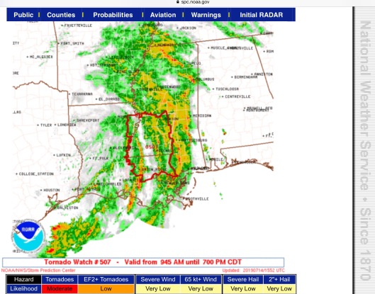
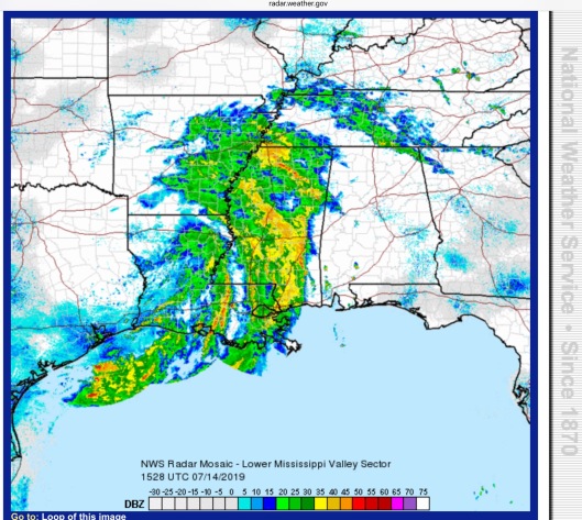
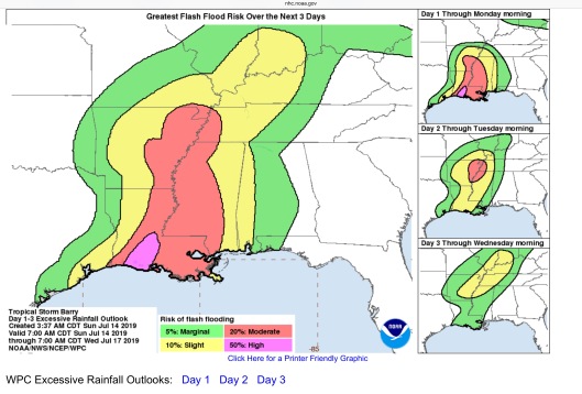
This information is mostly a few hours old, but useful to understand the impacts. It’s easy, based on the radar, to see how the outer bands/squall lines, which are/were impacting southeast Louisiana, Mississippi, Tennessee, Arkansas, and even Alabama, were from Barry’s bottom half in the Gulf, and have spun counterclockwise to the east and will probably spin around to the north and dump rain, as indicated on the 3 day flood map. We are adding the 1 pm NHC advisory, as well.
Our primary concern was and remains the area of Killona, Louisiana, where there is Waterford Nuclear Power Station, as well as petrochemical facilities, sitting on the Mississippi River and facing Lake Ponchartrain and facing near the Bonnet Carre spillway. Thus, we include a Killona forecast, further below. If the Bonnet Carre spillway is still open, as reported, then it would be important to know the impacts of Lake Ponchartrain storm surge, in conjunction with possible river storm surge, and full moon high tides. Waterford is sitting behind a levee, and somewhat waterproof, but the levee has been under record long duress due to Trump appointee to the MRC, Richard Kaiser, refusing to open the Morganza to alleviate stress of flood waters. The Morganza was built in the early 1950s for that purpose, so people in the spillway have known they are in the spillway for almost 70 years.
Multiple nuclear power stations are also at risk due to the possibility of wind-tree fall leading to power outages. Weirdly, nuclear power stations are dependent upon offsite power to operate. In the event of power outage they must depend upon backup diesel generators operating, which isn’t a given.
Bonnet Carre reported as still open: https://lasinkhole.wordpress.com/2019/07/14/sunday/
NWS Radar Mosaic – Lower Miss Valley 1528 UTC/1028 CDT 7/14/2019
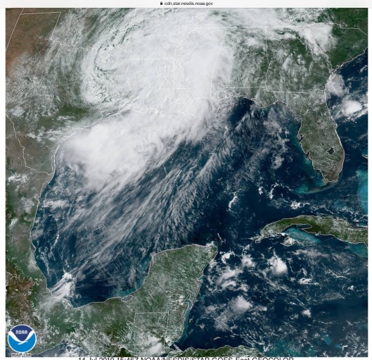
TS Barry Satellite 1546 Z (UTC)/1046 CDT
TS Barry Key Messages Adviory 17 10 AM CDT Sun July 14 2019
Excessive Rain Flash Flood Risk due to Barry 3 Day outlook July 14 2019 7 AM
TS and Hurricane Force Wind Swaths for Barry July 2019

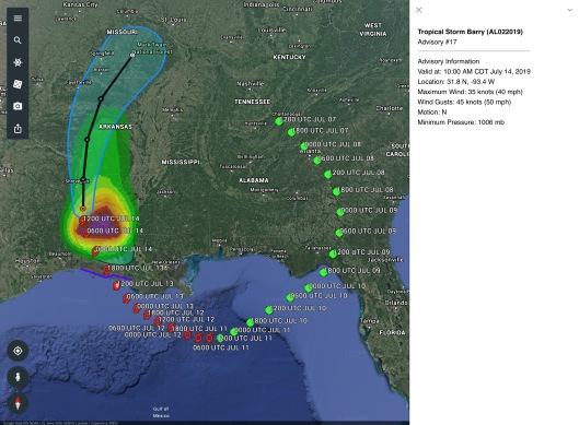
TS Barry past and future path as of 10 AM CDT July 14 2019
https://www.nhc.noaa.gov/refresh/graphics_at2+shtml/145922.shtml?ero#contents
Satellites: https://cdn.star.nesdis.noaa.gov/GOES16/ABI/SECTOR/gm/GEOCOLOR
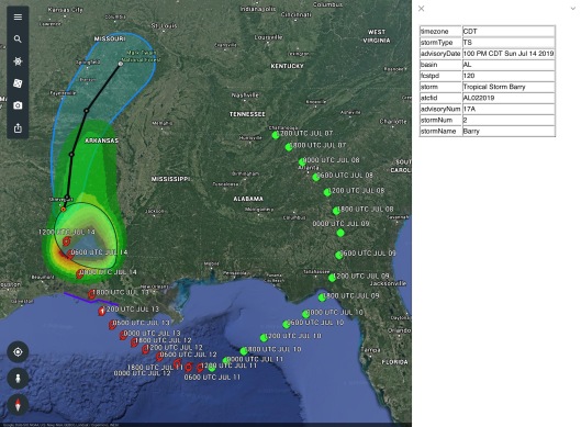
TS Barry past and future path as of 1 PM CDT July 14 2019
“958
WTNT32 KNHC 141747
TCPAT2
BULLETIN
Tropical Storm Barry Intermediate Advisory Number 17A
NWS National Hurricane Center Miami FL AL022019
100 PM CDT Sun Jul 14 2019
…BARRY CONTINUES GENERALLY NORTHWARD OVER NORTHWESTERN
LOUISIANA…
…LIFE-THREATENING FLOODING RAINS TO CONTINUE INTO MONDAY…
SUMMARY OF 100 PM CDT…1800 UTC…INFORMATION
———————————————-
LOCATION…32.4N 93.6W
ABOUT 15 MI…25 KM ESE OF SHREVEPORT LOUISIANA
MAXIMUM SUSTAINED WINDS…40 MPH…65 KM/H
PRESENT MOVEMENT…NNW OR 345 DEGREES AT 9 MPH…15 KM/H
MINIMUM CENTRAL PRESSURE…1007 MB…29.74 INCHES
WATCHES AND WARNINGS
——————–
CHANGES WITH THIS ADVISORY…
None.
SUMMARY OF WATCHES AND WARNINGS IN EFFECT…
A Tropical Storm Warning is in effect for…
* Morgan City to Cameron
A Tropical Storm Warning means that tropical storm conditions are
expected somewhere within the warning area. The Tropical Storm
Warning will likely be discontinued later this afternoon.
For storm information specific to your area, including possible
inland watches and warnings, please monitor products issued by your
local National Weather Service forecast office.
DISCUSSION AND OUTLOOK
———————-
At 100 PM CDT (1800 UTC), the center of Tropical Storm Barry was
located by NOAA Doppler radars and surface observations near
latitude 32.4 North, longitude 93.6 West. Barry is moving toward the
north-northwest near 9 mph (15 km/h). A general northward motion
is forecast tonight through Monday morning. A motion toward the
north-northeast and northeast is expected Monday afternoon into
Tuesday. On the forecast track, the center of Barry will move across
the northwestern portions of Louisiana today, and over Arkansas
tonight and Monday.
NOAA Doppler weather radar data and surface observations indicate
that maximum sustained winds remain near 40 mph (65 km/h) with
higher gusts. These winds are occurring near the coast well to
the southeast and south of the center. Weakening is expected as
the center moves farther inland, and Barry is forecast to weaken to
a tropical depression later today.
Tropical-storm-force winds extend outward up to 185 miles (295 km)
to the southeast of the center. A sustained wind of 41 mph (67 km/h)
and a gust to 48 mph (78 km/h) was recently reported at an NOS site
at Calcasieu Pass, Louisiana.
The estimated minimum central pressure is 1007 mb (29.74 inches).
HAZARDS AFFECTING LAND
———————-
Key Messages for Barry can be found in the Tropical Cyclone
Discussion under AWIPS header MIATCDAT2 and WMO header WTNT42 KNHC.
STORM SURGE: Water levels along the southern coast of Louisiana
are gradually receding. However, some minor coastal flooding is
still possible through today. For information specific to your
area, please see products issued by your local National Weather
Service forecast office.
RAINFALL: Barry is expected to produce rain accumulations of 6 to
12 inches over south-central Louisiana, with isolated maximum
amounts of 15 inches. Across the remainder of the Lower Mississippi
Valley, total rain accumulations of 4 to 8 inches are expected, with
isolated maximum amounts of 12 inches. This rainfall is expected to
lead to dangerous, life-threatening flooding.
WIND: Tropical storm conditions are occurring across portions of
the Tropical Storm Warning area, and these conditions will persist
through early this afternoon.
TORNADOES: A couple of tornadoes are possible today across portions
of southeastern Louisiana, Mississippi, western Alabama, eastern
Arkansas, and western Tennessee.
NEXT ADVISORY
————-
Next complete advisory at 400 PM CDT.
$$
Forecaster Stewart https://www.nhc.noaa.gov/text/refresh/MIATCPAT2+shtml/141445.shtml?
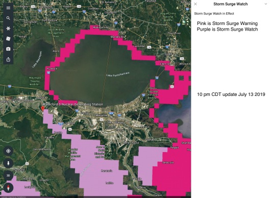
For the record, 10 pm update TS Barry Storm Surge Lake Ponchartrain – Mississippi River Near Waterford Nuclear Power Station. Killona advisories, below.
SEL7
URGENT – IMMEDIATE BROADCAST REQUESTED
Tornado Watch Number 507
NWS Storm Prediction Center Norman OK
945 AM CDT Sun Jul 14 2019
The NWS Storm Prediction Center has issued a
* Tornado Watch for portions of
East/Southeast Louisiana
Southern Mississippi
* Effective this Sunday morning and evening from 945 AM until 700
PM CDT.
* Primary threats include…
A couple tornadoes possible
SUMMARY…A strong wind field on the periphery of Barry will support
the possibility of low-topped supercells capable of a couple of
tornadoes through the afternoon/early evening.
The tornado watch area is approximately along and 50 statute miles
east and west of a line from 85 miles northeast of Natchez MS to 65
miles south southwest of Mc Comb MS. For a complete depiction of the
watch see the associated watch outline update (WOUS64 KWNS WOU7).
PRECAUTIONARY/PREPAREDNESS ACTIONS…
REMEMBER…A Tornado Watch means conditions are favorable for
tornadoes and severe thunderstorms in and close to the watch
area. Persons in these areas should be on the lookout for
threatening weather conditions and listen for later statements
and possible warnings.
&&
AVIATION…Tornadoes and a few severe thunderstorms with hail
surface and aloft to 0.5 inches. Extreme turbulence and surface wind
gusts to 60 knots. A few cumulonimbi with maximum tops to 400. Mean
storm motion vector 18045.
…Guyer
Top of Page/All Current Watches/Forecast Products/Home
https://www.spc.noaa.gov/products/watch/ww0507.html
https://www.nhc.noaa.gov/refresh/graphics_at2+shtml/145922.shtml?key_messages#contents
Wind history https://www.nhc.noaa.gov/refresh/graphics_at2+shtml/145922.shtml?swath#contents
Killona
Flood Statement
National Weather Service New Orleans/Baton Rouge, LA
1023 AM CDT Sun Jul 14 2019
…The flood warning is cancelled for the following rivers in
Louisiana…
Mississippi River At New Orleans affecting Jefferson…Orleans…
Plaquemines and St. Bernard Parishes
…The flood warning continues for the following rivers in
Louisiana…
Mississippi River At Baton Rouge affecting East Baton Rouge and West
Baton Rouge Parishes
Mississippi River At Donaldsonville affecting Ascension Parish
Mississippi River At Reserve affecting St. Charles…St. James and
St. John The Baptist Parishes
…The flood warning continues for the following rivers in
Louisiana…
Mississippi River At Red River Landing affecting East Baton
Rouge…Pointe Coupee and West Feliciana Parishes
PRECAUTIONARY/PREPAREDNESS ACTIONS…
Forecast crests are based upon rainfall that has occurred along with
anticipated rain for the next 24 hours. Adjustments to the forecasts
will be made if additional heavy rainfall occurs.
Do not drive cars through flooded areas. Remember, two feet of
rushing water can carry away most vehicles including pickups. Turn
around and don`t drown!
A followup product will be issued later. Stay tuned to NOAA Weather
Radio, local tv and radio stations…or your cable provider, for the
latest information. The latest graphical hydrologic information can
also be found at Weather.Gov.
&&
LAC089-093-095-152122-
/O.EXT.KLIX.FL.W.0020.000000T0000Z-190723T0000Z/
/RRVL1.1.ER.190226T1200Z.190714T0800Z.190722T1800Z.NO/
1023 AM CDT Sun Jul 14 2019
The Flood Warning continues for
The Mississippi River At Reserve.
* Until Monday July 22.
* At 9:00 AM Sunday the stage was 22.6 feet.
* Minor flooding is occurring and Minor flooding is forecast.
* Flood stage is 22.0 feet.
* Forecast…The river will continue to fall to below flood stage by
Monday July 22.
* Impact…At 22.0 feet…Marine and industrial interests along the
river, upstream barge operators, and facilities are impacted.
Navigation will become difficult for smaller river craft. Safety
precautions for river traffic are urged.
&&
LAT…LON 3007 9046 2999 9048 3001 9087 3009 9079
$$
Coastal Flood Advisory
Coastal Hazard Message
National Weather Service New Orleans LA
416 AM CDT Sun Jul 14 2019
…MINOR COASTAL FLOODING CONTINUES…
.Strong southerly winds over Southeast Louisiana coast, Lake
Pontchartrain, and Lake Maurepas will keep minor coastal flooding
and inundation in low lying and flood prone areas along Southeast
Louisiana coast and adjacent Parishes to Lake Pontchartrain and
Lake Maurepas through this afternoon.
LAZ040-050-058-060>062-064-066>070-072-141730-
/O.CON.KLIX.CF.Y.0007.000000T0000Z-190714T2100Z/
St. Tammany-Livingston-St. John The Baptist-St. Charles-
Upper Jefferson-Orleans-Upper St. Bernard-Lower Terrebonne-
Lower Lafourche-Lower Jefferson-Lower Plaquemines-
Lower St. Bernard-Southern Tangipahoa-
416 AM CDT Sun Jul 14 2019
…COASTAL FLOOD ADVISORY REMAINS IN EFFECT UNTIL 4 PM CDT THIS
AFTERNOON…
* COASTAL FLOODING…1 to 3 feet above ground level.
* IMPACTS…Minor inundation of low lying areas around bays and
the lower reaches of rivers and bayous. A few mainly secondary
roadways could become covered in water.
PRECAUTIONARY/PREPAREDNESS ACTIONS…
A Coastal Flood Advisory indicates that onshore winds and tides
will combine to generate flooding of low areas along the shore.
&&
$$
Flash Flood Watch
Flood Watch
National Weather Service New Orleans LA
400 AM CDT Sun Jul 14 2019
…FLASH FLOOD WATCH IS IN EFFECT THROUGH THIS EVENING…
.Bands of tropical showers and storms streaming off the gulf into
the circulation of Tropical Storm Barry will produce periods of
torrential rainfall that may result in flash flooding throughout
the day. As the remnants of Barry advances farther northward, the
influence will diminish over portions of the region, but some
narrow bands of heavy rain may linger into Monday. Based on
assessments from today`s expected rains, the flash flood watch may
need to be extended into Monday for portions of the watch area
later today.
LAZ034>037-039-040-046>050-056>072-MSZ068>071-077-080>082-150000-
/O.CON.KLIX.FF.A.0005.000000T0000Z-190715T0000Z/
/00000.0.ER.000000T0000Z.000000T0000Z.000000T0000Z.OO/
Pointe Coupee-West Feliciana-East Feliciana-St. Helena-Washington-
St. Tammany-Iberville-West Baton Rouge-East Baton Rouge-Ascension-
Livingston-Assumption-St. James-St. John The Baptist-
Upper Lafourche-St. Charles-Upper Jefferson-Orleans-
Upper Plaquemines-Upper St. Bernard-Upper Terrebonne-
Lower Terrebonne-Lower Lafourche-Lower Jefferson-
Lower Plaquemines-Lower St. Bernard-Northern Tangipahoa-
Southern Tangipahoa-Wilkinson-Amite-Pike-Walthall-Pearl River-
Hancock-Harrison-Jackson-
Including the cities of New Roads, Lettsworth, Livonia, Spillman,
St. Francisville, Wakefield, Jackson, Clinton, Felps, Darlington,
Easleyville, Greensburg, Montpelier, Bogalusa, Enon, Franklinton,
Slidell, Mandeville, Covington, Lacombe, Bayou Sorrel,
Plaquemine, White Castle, Port Allen, Addis, Brusly, Baton Rouge,
Gonzales, Donaldsonville, Prairieville, Denham Springs, Watson,
Walker, Pierre Part, Labadieville, Paincourtville, Convent,
Lutcher, Gramercy, Laplace, Reserve, Thibodaux, Raceland, Larose,
Destrehan, Norco, Metairie, Kenner, East New Orleans,
New Orleans, Belle Chasse, Chalmette, Violet, Houma, Bayou Cane,
Chauvin, Cocodrie, Dulac, Montegut, Galliano, Cut Off,
Golden Meadow, Leeville, Buras, Pointe A La Hache, Port Sulphur,
Boothville, Venice, Empire, Myrtle Grove, Yscloskey, Amite,
Kentwood, Roseland, Wilmer, Hammond, Robert, Ponchatoula,
Centreville, Dolorosa, Fort Adams, Woodville, Gillsberg, Gloster,
Smithdale, Liberty, McComb, Dexter, Salem, Tylertown, Crossroads,
McNeil, Poplarville, Picayune, Bay St. Louis, Waveland,
Diamondhead, Gulfport, Pascagoula, Ocean Springs, Moss Point,
Gautier, and St. Martin
400 AM CDT Sun Jul 14 2019
…FLASH FLOOD WATCH REMAINS IN EFFECT THROUGH THIS EVENING…
The Flash Flood Watch continues for
* portions of southeast Louisiana and Mississippi, including the
following areas, in southeast Louisiana, Ascension,
Assumption, East Baton Rouge, East Feliciana, Iberville,
Livingston, Lower Jefferson, Lower Lafourche, Lower
Plaquemines, Lower St. Bernard, Lower Terrebonne, Northern
Tangipahoa, Orleans, Pointe Coupee, Southern Tangipahoa, St.
Charles, St. Helena, St. James, St. John The Baptist, St.
Tammany, Upper Jefferson, Upper Lafourche, Upper Plaquemines,
Upper St. Bernard, Upper Terrebonne, Washington, West Baton
Rouge, and West Feliciana. In Mississippi, Amite, Hancock,
Harrison, Jackson, Pearl River, Pike, Walthall, and Wilkinson.
* through this evening
* Total rainfall accumulations of 2 to 4 inches with locally
higher amounts possible through this evening.
* Impacts include rapid rises on area small streams and creeks
resulting in flooding on some rivers. Rapid ponding of water
that may overwhelm local drainage capacities due to excessive
rain rates. Areas that don`t normally experience flash
flooding, could.
PRECAUTIONARY/PREPAREDNESS ACTIONS…
A Flash Flood Watch means that conditions may develop that lead
to flash flooding. Flash flooding is a very dangerous situation.
You should monitor later forecasts and be prepared to take action
should Flash Flood Warnings be issued.
&&
$$
24/RR
Hazardous Weather Outlook
Hazardous Weather Outlook
National Weather Service New Orleans LA
259 AM CDT Sun Jul 14 2019
GMZ530-532-534-536-538-550-552-555-557-570-572-575-577-LAZ034>037-
039-040-046>050-056>072-MSZ068>071-077-080>082-142000-
Lake Pontchartrain and Lake Maurepas-Mississippi Sound-
Lake Borgne-Chandeleur Sound-Breton Sound-
Coastal Waters from Port Fourchon LA to Lower Atchafalaya River
LA out 20 nm-
Coastal waters from the Southwest Pass of the Mississippi River
to Port Fourchon Louisiana out 20 NM-
Coastal Waters from Boothville LA to Southwest Pass of the
Mississippi River out 20 nm-
Coastal waters from Pascagoula Mississippi to Stake Island out
20 NM-
Coastal waters from Port Fourchon Louisiana to Lower Atchafalaya
River LA from 20 to 60 NM-
Coastal waters from Southwest Pass of the Mississippi River to
Port Fourchon Louisiana from 20 to 60 NM-
Coastal Waters from Stake Island LA to Southwest Pass of the
Mississippi River from 20 to 60 nm-
Coastal waters from Pascagoula Mississippi to Stake Island
Louisiana out 20 to 60 NM-Pointe Coupee-West Feliciana-
East Feliciana-St. Helena-Washington-St. Tammany-Iberville-
West Baton Rouge-East Baton Rouge-Ascension-Livingston-Assumption-
St. James-St. John The Baptist-Upper Lafourche-St. Charles-
Upper Jefferson-Orleans-Upper Plaquemines-Upper St. Bernard-
Upper Terrebonne-Lower Terrebonne-Lower Lafourche-Lower Jefferson-
Lower Plaquemines-Lower St. Bernard-Northern Tangipahoa-
Southern Tangipahoa-Wilkinson-Amite-Pike-Walthall-Pearl River-
Hancock-Harrison-Jackson-
259 AM CDT Sun Jul 14 2019
This Hazardous Weather Outlook is for portions of Southeast
Louisiana…South Mississippi and the adjacent coastal waters.
.DAY ONE…Tonight
A Flash Flood Watch remains in effect for the entire outlook area
through this evening, and may be extended in time for portions of
the area into tonight. Bands of tropical showers and storms
at times will be capable of producing torrential rainfall, gusty
winds 35 to 50 mph and occasional lightning. Flash flooding may
result under these bands.
There is a marginal risk of severe thunderstorms today and
tonight. The primary concern will be brief, weak tornadoes within
the bands of rain. Waterspouts in the near shore waters may move
ashore in the coastal areas before dissipating.
A Coastal Flood Advisory is in effect for minor and slowly
improving coastal flooding along the Louisiana coast and tidal
lakes today. Abnormally high tides 1 to less than 3 feet above
normal will be common this morning, but improving after high tide
this afternoon.
A Small Craft Advisory is in effect for the coastal waters and
tidal lakes through 7 am CDT this morning.
.DAYS TWO THROUGH SEVEN…Monday through Saturday
There will still be a threat of heavy rainfall from lingering
rain bands Monday. The outlook area should transition to a more
typical summer pattern of daily scattered afternoon thunderstorms
Tuesday through Saturday.
Depending on short-term rainfall trends, several area rivers and
streams may be in flood. Refer to the latest river flood
statements for more details.
.SPOTTER INFORMATION STATEMENT…
Spotter activation is still requested for flash flood monitoring
today.
$$

You must be logged in to post a comment.