
Tags
flooding, Gulf of Mexico, Lake Ponchartrain, Louisiana, rainfall, Storm Surge, Tropical Storm, Tropical Storm Barry, Tropical Storm Barry advisory, Tropical Storm Barry landfall, Tropical Storm Barry location, US Gulf Coast, Warnings, Watches, Waterford nuclear power station
This blog posts as UTC. It is still July 12th in the United States (mainland).
https://www.nhc.noaa.gov/refresh/graphics_at2+shtml/024821.shtml?key_messages#contents
“000
WTNT32 KNHC 130246
TCPAT2
BULLETIN
Tropical Storm Barry Advisory Number 11
NWS National Hurricane Center Miami FL AL022019
1000 PM CDT Fri Jul 12 2019
…BARRY EXPECTED TO BECOME A HURRICANE BEFORE REACHING THE
SOUTH-CENTRAL COAST OF LOUISIANA…
…DANGEROUS STORM SURGE, HEAVY RAINS, AND WIND CONDITIONS
EXPECTED ACROSS THE NORTH-CENTRAL GULF COAST…
SUMMARY OF 1000 PM CDT…0300 UTC…INFORMATION
———————————————–
LOCATION…28.6N 91.0W
ABOUT 75 MI…125 KM S OF MORGAN CITY LOUISIANA
ABOUT 120 MI…195 KM WSW OF THE MOUTH OF THE MISSISSIPPI RIVER
MAXIMUM SUSTAINED WINDS…65 MPH…100 KM/H
PRESENT MOVEMENT…WNW OR 300 DEGREES AT 3 MPH…6 KM/H
MINIMUM CENTRAL PRESSURE…993 MB…29.33 INCHES
WATCHES AND WARNINGS
——————–
CHANGES WITH THIS ADVISORY…
None.
SUMMARY OF WATCHES AND WARNINGS IN EFFECT…
A Hurricane Warning is in effect for…
* Intracoastal City to Grand Isle
A Tropical Storm Warning is in effect for…
* Mouth of the Pearl River to Grand Isle
* Lake Pontchartrain and Lake Maurepas including metropolitan New
Orleans
* Intracoastal City to Cameron
A Storm Surge Warning is in effect for…
* Intracoastal City to Biloxi
* Lake Pontchartrain
A Storm Surge Watch is in effect for…
* Biloxi to the Mississippi/Alabama border
A Hurricane Watch is in effect for…
* Mouth of the Mississippi River to Grand Isle
* Intracoastal City to Cameron
A Tropical Storm Watch is in effect for…
* East of the Mouth of the Pearl River to the Mississippi/Alabama
border
A Hurricane Warning means that hurricane conditions are expected
somewhere within the warning area. A warning is typically issued
36 hours before the anticipated first occurrence of
tropical-storm-force winds, conditions that make outside
preparations difficult or dangerous. Preparations to protect life
and property should be rushed to completion.
A Tropical Storm Warning means that tropical storm conditions are
expected somewhere within the warning area within 36 hours.
A Storm Surge Warning means there is a danger of life-threatening
inundation from rising water moving inland from the coastline
during the next 36 hours in the indicated locations. For a
depiction of areas at risk please see the National Weather
Service Storm Surge Watch/Warning Graphic available at
hurricanes.gov. This is a life-threatening situation. Persons
located within these areas should take all necessary actions to
protect life and property from rising water and the potential for
other dangerous conditions. Promptly follow evacuation and other
instructions from local officials.
A Storm Surge Watch means there is a possibility of life-
threatening inundation from rising water moving inland from the
coastline in the indicated locations during the next 48 hours.
A Hurricane Watch means that hurricane conditions are possible
within the watch area. A watch is typically issued 48 hours
before the anticipated first occurrence of tropical-storm-force
winds conditions that make outside preparations difficult or
dangerous.
A Tropical Storm Watch means that tropical storm conditions are
possible within the watch area generally within 48 hours.
For storm information specific to your area, including possible
inland watches and warnings, please monitor products issued by your
local National Weather Service forecast office.
DISCUSSION AND OUTLOOK
———————-
At 1000 PM CDT (0300 UTC), the center of Tropical Storm Barry was
located near latitude 28.6 North, longitude 91.0 West. Barry is
moving toward the west-northwest near 3 mph (6 km/h). A motion
toward the northwest should begin overnight, followed by a turn
toward the north Saturday night or Sunday. On the forecast track,
the center of Barry will approach the south-central coast of
Louisiana tonight and then make landfall along the south-central
Louisiana coast on Saturday. After landfall, Barry is expected to
move generally northward through the Mississippi Valley through
Sunday night.
Maximum sustained winds are near 65 mph (100 km/h) with higher
gusts. Strengthening is forecast before landfall, and Barry is
expected to be a hurricane when the center reaches the Louisiana
coast on Saturday. Weakening is expected after Barry moves inland.
Tropical-storm-force winds extend outward up to 175 miles (280 km)
from the center. An observation platform at South Timbalier Block
off the coast of Louisiana has recently reported a sustained wind
of 47 mph (76 km/h) with a gust to 59 mph (94 km/h).
The estimated minimum central pressure is 993 mb (29.33 inches).
HAZARDS AFFECTING LAND
———————-
Key Messages for Barry can be found in the Tropical Cyclone
Discussion under AWIPS header MIATCDAT2 and WMO header WTNT42 KNHC.
STORM SURGE: The combination of a dangerous storm surge and the
tide will cause normally dry areas near the coast to be flooded by
rising waters moving inland from the shoreline. The water could
reach the following heights above ground somewhere in the indicated
areas if the peak surge occurs at the time of high tide…
Intracoastal City to Shell Beach…3 to 6 ft
Shell Beach to Biloxi MS…3 to 5 ft
Lake Pontchartrain…3 to 5 ft
Biloxi MS to the Mississippi/Alabama border…2 to 4 ft
Lake Maurepas…1 to 3 ft
Surge-related flooding depends on the relative timing of the surge
and the tidal cycle, and can vary greatly over short distances. For
information specific to your area, please see products issued by
your local National Weather Service forecast office.
RAINFALL: Barry is expected to produce total rain accumulations of
10 to 20 inches over south-central and southeast Louisiana and
southwest Mississippi, with isolated maximum amounts of 25 inches.
These rains are expected to lead to dangerous, life threatening
flooding over portions of the central Gulf Coast into the Lower
Mississippi Valley beginning as early as Saturday morning. Across
the remainder of the Lower Mississippi Valley, total rain
accumulations of 4 to 8 inches are expected, with isolated maximum
amounts of 12 inches. By early next week, Barry is expected to
produce rainfall accumulations of 4 to 8 inches across western
portions of the Tennessee Valley.
WIND: Hurricane conditions are expected in the Hurricane Warning
area later tonight or Saturday, with tropical storm conditions
currently spreading across the area. Hurricane conditions are
possible within the Hurricane Watch area tonight or Saturday
morning. Tropical storm conditions are occurring across the
Tropical Storm Warning area in southeastern Louisiana at this time.
Tropical storm conditions are possible in the Tropical Storm Watch
area by tonight or Saturday. Wind gusts to tropical-storm force in
squalls are possible along portions of the coasts of Alabama and the
western Florida Panhandle through Saturday night.
TORNADOES: A couple tornadoes are possible late tonight through
Saturday across southeast Louisiana and southern Mississippi.
NEXT ADVISORY
————-
Next intermediate advisory at 100 AM CDT.
Next complete advisory at 400 AM CDT.
$$
Forecaster Brown
https://www.nhc.noaa.gov/text/refresh/MIATCPAT2+shtml/130246.shtml
179
WTNT42 KNHC 130247
TCDAT2
Tropical Storm Barry Discussion Number 11
NWS National Hurricane Center Miami FL AL022019
1000 PM CDT Fri Jul 12 2019
The overall satellite presentation of Barry has improved since this
afternoon. The center is located closer to the main convective
mass and there has been some expansion of the cirrus outflow. There
has also been an increase in the convective banding over the eastern
and southeastern portions of the circulation. Both NOAA and Air
Force Reserve reconnaissance aircraft have been in the storm this
evening. The NOAA aircraft found peak 700 mb flight-level winds of
64 kt in the southeastern quadrant, which still supports an initial
intensity of 55 kt.
Barry has been able to strengthen over the past day or so despite
northerly shear and dry mid-level air. With the recent increase in
convection near the center and the expansion of the upper-level
outflow, it appears that the shear over the center has decreased.
As a result, the NHC intensity forecast calls for Barry to become a
hurricane before it reaches the coast of Louisiana. Although this
is slightly above the intensity guidance, most of the dynamical
models show some modest deepening before landfall. After the
center moves inland, steady weakening is expected and the system
is predicted to become a remnant low in about 72 hours.
Barry has been meandering over the past several hours, but the
longer term motion is 300/3 kt. The storm is expected to turn
northwestward overnight as a weakness develops in the subtropical
ridge that extends over the southeastern United States. This should
bring the center of the storm onshore along the south-central coast
of Louisiana on Saturday. By Saturday night or early Sunday, Barry
is forecast to turn northward around the western portion of the
aforementioned ridge. Barry or its remnants should recurve into
the mid-latitude westerlies by late Monday. Although the guidance
envelope has shifted slightly westward again this cycle, the NHC
track is virtually unchanged and is closest to the typically
reliable GFS and ECMWF models which lie along the eastern side
of the envelope.
Key Messages:
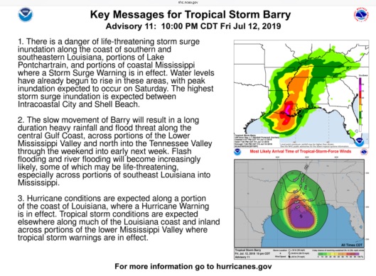
1. There is a danger of life-threatening storm surge inundation
along the coast of southern and southeastern Louisiana, portions of
Lake Pontchartrain, and portions of coastal Mississippi where a
Storm Surge Warning is in effect. Water levels have already begun
to rise in these areas, with peak inundation expected to occur on
Saturday. The highest storm surge inundation is expected between
Intracoastal City and Shell Beach.
2. The slow movement of Barry will result in a long duration heavy
rainfall and flood threat along the central Gulf Coast, across
portions of the Lower Mississippi Valley and north into the
Tennessee Valley through the weekend into early next week. Flash
flooding and river flooding will become increasingly likely, some of
which may be life-threatening, especially across portions of
southeast Louisiana into Mississippi.
3. Hurricane conditions are expected along a portion of the coast of
Louisiana, where a Hurricane Warning is in effect. Tropical storm
conditions are expected elsewhere along much of the Louisiana coast
and inland across portions of the lower Mississippi Valley where
tropical storm warnings are in effect.
FORECAST POSITIONS AND MAX WINDS
INIT 13/0300Z 28.6N 91.0W 55 KT 65 MPH
12H 13/1200Z 29.3N 91.5W 65 KT 75 MPH
24H 14/0000Z 30.4N 92.1W 50 KT 60 MPH…INLAND
36H 14/1200Z 31.5N 92.4W 35 KT 40 MPH…INLAND
48H 15/0000Z 32.9N 92.5W 25 KT 30 MPH…INLAND
72H 16/0000Z 35.8N 92.4W 20 KT 25 MPH…POST-TROP/REMNT LOW
96H 17/0000Z 38.7N 90.2W 15 KT 15 MPH…POST-TROP/REMNT LOW
120H 18/0000Z…DISSIPATED
$$
Forecaster Brown
https://www.nhc.noaa.gov/text/refresh/MIATCDAT2+shtml/130247.shtml

You must be logged in to post a comment.