
Tags
A-Area, dangers of nuclear, environment, F-area, fire hazard, hydrogen fires, liquid radioactive waste tanks, N site, N-Area, nuclear, nuclear accident, nuclear fires, nuclear industry, nuclear safety, nuclear waste, nuclear waste fires, nuclear weapons, plutonium, radiation, radioactive fire, radioactive waste, risk management, Savannah River Nuclear Site, SRNL, SRS, tritium, US DOE, USA, water
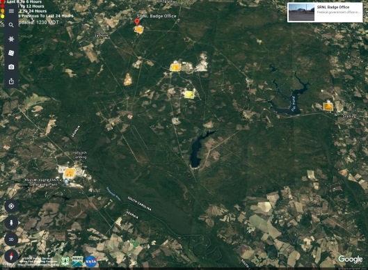
Earlier fires with discussion of areas-maps:
Fire at H-Area of the Savannah River Nuclear Site, August 7th 2016?
The fires listed below, sensed from space, may or may not be accurate. http://activefiremaps.fs.fed.us/index.php Without confirmation on the ground, it is impossible to know for sure.
Area A

“Latitude: 33.340
Longitude: -81.737
Detection Date: 29 Jun 2018
Detection Time: 18:30 UTC
Confidence: 68
Sensor: Aqua MODIS
Source: SSEC”
F Area? Shipping containers of waste?

“Latitude: 33.285
Longitude: -81.675
Detection Date: 29 Jun 2018
Detection Time: 18:30 UTC
Confidence: 68
Sensor: Aqua MODIS
Source: SSEC”
N Site?
“Latitude: 33.248
Longitude: -81.652
Detection Date: 26 Jun 2018
Detection Time: 16:23 UTC
Confidence: 39
Sensor: Terra MODIS
Source: GSFC_DRL”
Vogtle (Seems to be the construction site for new Vogtle reactors)
“Latitude: 33.141
Longitude: -81.771
Detection Date: 29 Jun 2018
Detection Time: 18:30 UTC
Confidence: 38
Sensor: Aqua MODIS
Source: SSEC”
Unknown site in the area of Energy Solutions-Barnwell site
“Latitude: 33.141
Longitude: -81.771
Detection Date: 29 Jun 2018
Detection Time: 18:30 UTC
Confidence: 38
Sensor: Aqua MODIS
Source: SSEC”


Fire maps, details, disclaimer: http://activefiremaps.fs.fed.us/index.php
Savannah River Site labeled maps: https://cryptome.org/eyeball/srs/srs-eyeball.htm

You must be logged in to post a comment.